This blog contains accounts of my travels in India and abroad. Some of the posts were created much later, the dates have been adjusted to give a sense of the real time.

Saturday, December 11, 2010

Puri


Pictures of Lord Jaganath and other items (including a mini Ashoka chakra) being sold near the Jaganath temple

Monday, October 25, 2010

Gurudongmar -Three's company


The engine refused to start! The driver relentlessly repeated the ignition sequence, but the sound of the engine died down each time and with it, our hopes of getting to Yumthang. Not only are our travel plans in jeopardy, but our safety – we are over 13,000 ft up, in the middle of nowhere. It is close to midday, but outside the vehicle, the rain assists the temperatures in plummeting to single digits. Worse still, the closest form of civilisation – the village of Thanggu – is about a half hours drive away. Our driver it seems has tried everything and is now beckoning us out of the car. I look around towards RM and JC. The anxious look on their faces expresses a similar disappointment.
Lachen to Gurudongmar lake

Ice breakers on the road
RM and JC have been acquaintances of mine for about 40 hours. They on the other hand have been friends since school. Our decision to travel through north Sikkim together mimicked an effort of coalition politics rather than a happenstance meeting of friendly, similar minded beings. A trip to Gurudongmar and Yumthang valley was proving to be too expensive for either of us, separately. But lady luck was on our side that evening, and all three of us stepped into the travel agent’s office on MG Marg, Gangtok at approximately the same time, making the suggestion a no-brainer for the travel agent.  It was weird, that first meeting, each one trying to figure the other out - like two dogs introduced to each other by their owner – sniffing each other for any signs of danger– the accent, attire, unnecessary body marks. But the foremost fear in my mind was whether or not these guys were really travellers! Will they keep puking out the car window throughout the journey? Would they buckle under the heights of Gurudongmar? Will they expect a better hotel at Lachen and cry foul? But as always, the predominant urge to travel allowed me look beyond all possible shortcomings.
Our conversations in the Maxx, the next day were limited to small talk – our work, education, families. None wanted to make any bold comments or suggestions. Inevitably, though as it would seem, conversations drifted onto travel itself. A few weeks before, the duo had travelled to Lava which is about 30-odd kms from Kalimpong in North Bengal. The excitement in their narration of the events was apparent. And as they described, with an air of wonder and devotion, the glimpse they caught of Mt. Kangchendzonga through the clouds, I laid to rest my fears of my companions. They certainly weren’t just dreamers.  I, in turn, having been to Kalimpong and Pedong earlier in the year eagerly exchanged notes with them. It was now their fears that were to be allayed with tales of pursuit of a lost Bhutanese fort (which I never reached, by the way), the leeches, the clouds and all things hidden in the forgotten hills that would gladden a wanderer’s heart.

Lachen (“Big Pass”)
The village of Lachen
The ice was now broken! In the assurance that none of us would by inclinations or frailty endanger the journey, the chronicles of our ramblings and experiences unfolded – from Kolkata to the North-east to the nation’s capital and my home city of Bombay (Mumbai). Anecdotes that took us past the dusty district capital of Mangan , the beautiful and meandering Teesta, the reticent village of Chungthang at the confluence of the Lachen and Lachung and finally into the village of Lachen just after dusk.
Lachen was oddly comforting – beating my expectations, there were double and triple storeyed houses and hotels, with satellite dishes protruding from the sides giving you that feeling of being connected to the world you have left behind. Darkness however kept from me, her bountiful surroundings – of green wooded slopes, with patches of autumn yellow, of stealth clouds and the silent but ever moving Lachen river. In any case, exploration of the town was to be deferred – not only because of the curbs of caliginosity, but also the requirements of the next day. Vehicles are not allowed to the lake after 12 noon as the conditions then deteriorate and make the place inhospitable. An early dinner and early start in the morning was due.

Gurudongmar-water on the moon
Thanggu


An Army run cafe on the way- apparently the world's highest!

The drive from Lachen began before sunrise at around 4:30 in the morning. The landscape around that was sparsely peppered with fields and single houses, appeared in shades of grey under the awaited sun. Only the tops of the mountains, usually the first to feel her warmth, could be seen albeit through filters of orange. We made an early stop at the village of Thanggu, where we are guided into a local home for breakfast – bread with hot, molten butter poured over it, to be eaten hot before it froze back again.
Yak herder's hut
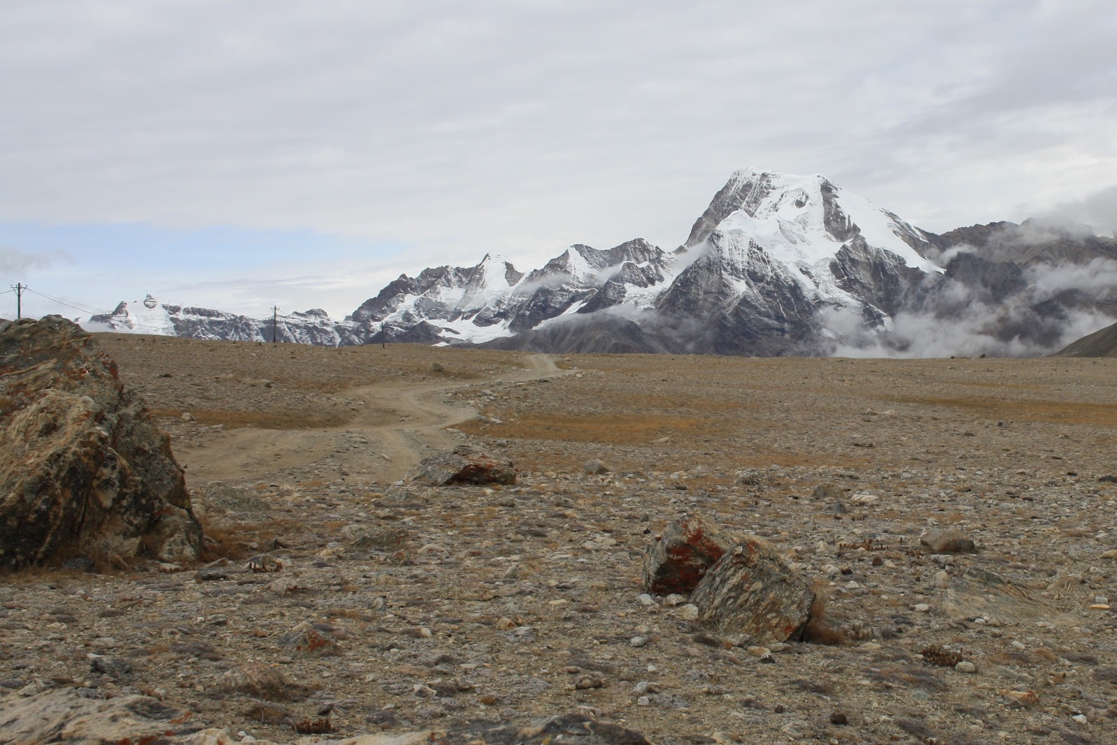
Thanggu is at 14,000 ft and after the village the tree line recedes to give way to the vast desert plateau.  It’s a concoction of comatose gravel and stone stretching across acres, with the icy mountain ranges on the sides, standing tall and firm like organised battalions. If only a herd of horses were to gallop across the vast space, with purpose and freedom, so that movement, life and sound may render this portrait complete! But alas, the only four legged animal you are likely to spot is the Yak. You will find them grazing on the patches of grass that miraculously found a way to survive here or near the herders’ huts – crude stone structures with attached enclosures.
The lonely, desolate road to Gurudongmar
Back in the Maxx, RM’s head was tilted back. He was trying to sleep off the mountain sickness that has gripped him. Later, at lower altitudes, he spoke of the flashes of tragic events and nightmares that he experienced during his sleep – the oxygen levels must have really been low.  
When we arrived at the lake, a few moments later, it was similar to desert voyagers sighting an oasis. Gurudongmar lake might have gallons of water, but it’s not bodily thirst that one quenches here. Her demeanour is more spiritual - the placid waters, the remoteness of the mountains, the strings of prayer flags that adorn her banks and of course the Sarva Dharma Sthal (House of worship for all religions) is a good representation of her past.


Gods of the lake
Gurudongmar lake gets its name from Guru Padmasambhava (Guru Rinpoche). Sikhs believe that Guru Nanak (also known as Guru Dongmar)was known as guru Rinpoche to the Tibetans. Either way, both are believed to have passed through these parts.
(http://www.east-himalaya.com/sikkim/gurudongmar.html, http://www.sikhiwiki.org/index.php/Gurudongmar_Lake)

Gurudongmar Lake

Tibetan prayer flags add to the spiritual ambience

There isn’t much to do around here, except for soaking in the tranquillity and taking wonderful pictures. After we are through with that, we scampered to the Maxx for a quick return to Lachen and then onward to Lachung and Yumthang. But, now about two hours later, we are huffing and puffing as we try to push the Maxx into life – she doesn’t. We spot an army post up ahead and request some engineers to have a look.  The fuel filter is detected as the culprit – it must be the fuel that was bought from the makeshift station right after Gangtok. In desperation, the filter is removed, but the Maxx still refuses to co-operate. There is now no hope of getting to Yumthang.

Rescue
Finally, after options are knocked off, the army generously offers us a ride to Lachen. A truck would be crossing the village en route to another post and we are offered a lift. It’s an interesting turn of events, a chance to ride with our armed forces in one their vehicles, even though it’s as peaceful a mission possible. As we clamber into the back, one of the jawans yells to us with a smirk, “You will remember this ride for the rest of your life!” as he gets behind the wheel.
The ride is as rough as it gets – we find ourselves tumbling from one end of the truck to the other, first in shock and then with playful frolic as with a roller coaster. Outside, humans are still scarce, but life as we know begins show up in patches of green, yellow and orange amidst the conifers. The lichen and rhododendrons sprinkle more colour on the canvas. These are the vistas that I lost in the morning, partly to the darkness, partly to my reclamation of sleep. We are closing in on Lachen. I suddenly realise that our travelling group is now four – in the corner, is the driver of the Maxx, anxious as ever. He needs to find a mechanic from somewhere and take him to the point where we left the vehicle. He is looking at severe losses of repair, time and opportunity. I wonder if he has any travel stories –perhaps now is not the right time.


Pointers

  •      Whether Indian or foreigner, you will be travelling close to India’s borders and you require a permit to cross Mangan. These permits can be attained from recognised travel agents which can be found in plenty on MG Marg, Gangtok. However, no agent is willing to just deal in permits – you will have to make all arrangements of travel through them.
  •      You will identity proofs and photographs of yourself for the same. Foreigners should carry their passports.

Saturday, September 4, 2010

North Bengal

Football match at Pedong

Pipe organ an St. Theresa's Church, Kalimpong

Ghum, the highest railway station in India

Darjeeling Himalayan Railway ("Toy train") at Batasia loop, Darjeeling

The fight for gorkhaland goes on! (pic taken in Kurseong)

Tea plantations in Kurseong

Monday, September 21, 2009

Stopover in Lahaul - Keylong


It was thrilling to peer down at the panorama below – the green canopy dotted with tiny houses, the fields and the winding roads on the mountain slopes -a somewhat familiar yet satisfying experience, especially since I wasn’t looking at river fed plains from just another hill station – this was the Kullu valley, already at over 1,500 mts! We are taking the last few curves in the road before we cross Rohtang la (3998 mts) into Lahaul. (This time with a colleague of mine, SP)
You follow the Chandra river (above) till Tandi, from then on it's the Bhaga
The Rohtang pass is often visited by tourists in Manali – It is a sure way to touch and feel snow, which for largely tropical dwelling Indians is a fantasy in itself. But, today I want to cross over to the other side of the pass. A quick glance towards the end of the road before it turns left and down into Lahaul, reveals snow capped ranges with mountain sides barren and bereft of life. We were now moving into the famous cold desert of North India, which stretches from Himachal Pradesh to Ladakh.
After stopping briefly at the pass to watch the setting sun turn the mountain tops orange, we hasten in the descent – the roads aren’t the best and we need to make the best of whatever light we have. We arrive at 8pm in a half-shut Keylong and make a beeline for Tashi Deleg, one of the better hotels near our drop off point and the marketplace.

Desert capital
Keylong, at over 3,000 mts is the capital of the Lahaul-Spiti district in Himachal Pradesh. She sits timidly on the banks of the Bhaga waiting to be discovered by travelers. The truth is many travelers do stop here. Given that it is a district capital, you will get mobile connectivity, a hospital if required, plenty of shops and hotels. It therefore becomes a convenient night halt for those going from Manali to Leh. But unfortunately, that’s how it remains – a night halt. That shouldn’t take anything away from the fact that it is a really picturesque little village. But before we explore Keylong and her people, we head out for a rendezvous with one of the highest lakes in India – Suraj Tal

Barren Lahauli landscape

 Water on high

When you are travelling through the hills, you inevitably end up following a river which is natural considering the landscape that it creates. Today, we travel along the Bhaga, still on the Manali-Leh highway. We soon leave the fields of Keylong, there isn’t any green to be seen anymore, only shades of brown with fine blue lines of the Bhaga creating a vein-like pattern over the land. After crossing the check post at Darcha, the climb gets steeper and the terrain still harsher. Landslides are more common and we are halted several times. This lifeless spectacle will continue for the rest of the journey. 
Landslides are common (Darcha down below)
For an urbanite, brought up in the one of the most populous cities in the world, the isolation is absolutely exciting.  It makes we wonder how much of a risk we are taking, traversing these parts in a Maruti van.

You can get some great reflections at Deepak Tal
Our first stop is at Deepak Tal near Patseo. It is just large enough to not be called a pond, but is definitely worth the visit. It’s crystal clear and the still waters are a photographer’s delight.  It’s also a nice place to stop before you ascend towards Baralacha La.
Baralacha La is one the higher passes on this route and the ascent can be taxing on your lungs, but it’s worth the effort. The scenery now starts to turn white – frost covers the sides of the road and the snow covered peaks that complete the horizon of the lower villages now seem closer than ever. We never really reached the pass – Suraj Tal, our real destination is just short. The L-shaped lake springs up on you without warning – not that you need one to appreciate its pristine settings. But the lifeless nature of the surroundings continues- we are the only ones here and it doesn’t seem like a much frequented spot anyway.
Suraj Tal

Khardung monastery
There are a few treks around Keylong - to her monasteries that sit atop her high mountains. We find ourselves heading towards the east bank to the Khardung monastery that overlooks the town. You pass the hospital, cross the prayer flag strewn metal bridge and begin climbing towards the monastery. The route takes you through Lahaul at its best. Away from the hotels, the bus stand and the main market on the west bank, Khardung village is a picture postcard of Lahauli village life with potato fields, cubical houses with flat roofs storing hay for the harsh winters, narrow dusty roads devoid of tire marks and the scampering of children and sheep alike in between. The people are friendly and will gladly engage you in conversation. Even the women are fairly bold – we had a bunch that stopped us to ask us for some chocolate!
Potato fields in Khardung village

This man claimed that the original Khardung monastery was down in the village and that he  was  its keeper. 

Got any chocolate?
1.5 hrs of climbing and we are finally there. Khardung monastery is a dainty white building with the front façade decorated with images of animals and men. The courtyard is lined with flower pots, a statue of the Buddha and prayer flags. Apart from that, it was quite the expected - monks solemnly moving around, prayer wheels, prayer flags and pin drop silence. One of the monks comes out to give us a tour of the monastery. The monastery belongs to the Drukpa Kargyud sect and is adorned with paintings on all sides. It also houses some ancient artifacts. But this isn’t the original building – the monastery has been destroyed and rebuilt several times before.
Khardung monastery

The highlight though, is the eagle-eye view of Keylong, right across the river where she lies nestled on the banks,  waiting for the next traveller to Leh to stop by– a perfect fusion of human life, marketplaces, quaint houses, terraced fields and a lifeless desert in the background with God himself standing guard over her!
Keylong from the monastery


Pointers
  • If you are taking your own vehicle, tank up at the Petrol pump at Tandi. It is the last one until Leh.
  • The roads are often washed away due to rains, melting snow etc and inspite of frequent repair remain in bad shape – account for plenty of time for travel (Manali to Keylong took 6 hrs for a distance of 120kms)
  • There are plenty of hotels in Keylong of which the Chandrabaga is probably the best. However, it is not the closest to the market place. You can also choose to stay at the hotel Ibex at Jispa.

Monday, August 17, 2009

On the Guru's trail - The Valley of flowers


“Our happiest moments as tourists always seem to come when we stumble upon one thing while in pursuit of something else.” — Lawrence Block

Little Ludhiana
“This is like a little Ludhiana!”, exclaimed +Vinay Sekar  as he looked at the hordes of pilgrims. I join him to see a sea of turbans bobbing up and down in the main street of Govindghat. Along with it, I can hear the distinctive yet familiar beat of Bhangra music – I really can’t blame VS for that comment.  
Govindghat which is propped on the banks of the Alakananda is just one narrow street, packed with vendors selling everything from apparel to Punjabi music CDs. Now, if you are looking for Govindghat in the map of Punjab, you are in the wrong state. I am in the hill state of Uttaranchal, with the hope of getting to the fairy tale ‘valley of flowers’.  Most of the pilgrims on the other hand are on their way to Hem Kund Sahib, a Sikh pilgrimage point.
Route from Govindghat to the valley of flowers

If you are not familiar with the trail, here goes - You start off from Govindghat, which is 24 km from Joshimath. This is as far as wheels can take you, from here is either horseback or on foot. Starting at Govindghat is the long arduous trek of 14kms to Ghangaria, which serves as a base for treks to the Valley of flowers and HemKund Sahib. The Valley of Flowers is about 3km from Ghangaria and Hemkund Sahib, around 6km.
VS and I are joined by a colleague of mine AS, and his friend. We start of in the early evening, hoping to make it to Ghangaria by around 9-10 pm. But fate had other plans, and what we then thought was an ‘unfortunate’ series of events, soon became a unique travelling experience.
 First, one succumbs to the trek and the higher altitudes, then off comes the sole of another’s shoe, rain, darkness, rumours of bears ahead and in about 2 hours we are embarrassingly headed back to Govindghat only to find that every room is booked solid. Our only hope is the Gurudwara here in Govindghat.

Govindghat

A lesson in Sikh etiquette
Owing to the large number of pilgrims to HemKund, the Gurudwara not only provides spiritual comfort, but some more temporal ones as well – a guesthouse for the not so affluent and perhaps ones like us – stranded without shelter, even if you aren’t Sikh. It has a few rooms and a large dormitory – spartan no doubt, but bear in mind that all this runs on just donations! A bit of pleading is required – the guesthouse is also full, even the dorm! But AS (who is Sikh himself) finally gets them to let us sleep on the common balcony. But the good Sikh hospitality didn’t end there – we are soon ushered into a large dining hall for langar.


What is langar?
The word langar (लंगर) can be traced back to Persian- it means ‘an alms house’, 'an asylum for the poor and the destitute' or 'a public kitchen kept by a great man for his followers and dependents, the holy men and the needy.' In the case of Sikhism, it’s more of the third. Langar is also known as Guru-ka –langar (langar in the name of the guru). It was first started by Guru Nanak to demonstrate the principle of equality. In the hall, everyone irrespective of social status gather to eat. However, this isn’t a simple dinner – food is often blessed in the Gurudwara and then mixed with the rest –so it is considered sacred and referred to as ‘Guru-prashad’. The kind of food and the frequency of service depends solely on the resources of the Gurudwara- money/food donated and volunteers to prepare and serve the food.

[I have written this note with the help of internet resources (http://www.searchsikhism.com/institution.html, http://www.sikhiwiki.org/index.php/Langar) and a few friends-Thanks +Alamjit Singh Sekhon and +Supriya Bhogal . If you need more information, there is enough on the net. You can also contact your friendly neighbourhood Sardar]


We cover our heads with handkerchiefs or any cloth that we have on hand and remove our sandals before we enter. It’s my first time in a Gurudwara premises and I’m certainly quite self-conscious. After we sit, volunteers or sevadars come around serving us dal, vegetable and rotis. He comes to me to serve offer me a roti and drops it in my plate – no big deal right? But then, I look towards AS who receives his roti with two open palms and head bent down in reverence. Okay so that’s one goof up – I guess I’m allowed one mistake right? Towards the end of my meal, the sevadar returns to serve me some more. This time, I am determined to be extra respectful and reply with my politest ‘No Thank You’ and a smile. I then turn to AS again, with the fear and suspense of a quiz participant, hoping that his calculated guess turns out to be right. But AS, who is also done with his meal, again lowers his head,  covers his plate with both palms facing down and says ‘Bas’ . I look around to see if anyone is disturbed by my blatant discourtesies, but everything seems to be fine. I guess, when you are dark skinned and 5 feet 6 inches tall, people sort of know you‘re not from the Punjab! But one piece of tradition I did manage to follow was to wash my plate – it is compulsory for all to do so. Regardless of my ill-mannered behaviour, I do feel a certain humility present in the gathering, an equality that redefines people’s roles to fulfil the most basic of human needs. It reinforces a belief I have always held – only Religion can achieve true equality of men, where the haves and have-nots are only too happy to oblige.
We collect our sheets and blankets and head to the balcony – there is a roof over our heads for the night!
Garden of Eden
We start again at the break of dawn the next morning, but take mules to catch up on lost time – embarrassing, yes, but it is the fastest way up to Gangaria. With the Valley of flowers trek, it’s a case of the journey being as captivating as the destination. The route to Gangharia runs along the Lakshman Ganga River and sound of the roaring river accompanies you all the way. There was ofcourse for us the added monsoon bonus of lush green mountains with waterfalls gushing and sparkling on their way down. The journey lasted just  4.5 hours- those mules are quick!
Village on the way
Gangaria is a collection of luxury tents, guesthouses and horse owners trying to get customers going back down to Govindghat. And standing amidst all this is a helipad. So much for the mules being the fastest transportation! It is at this point that the pilgrims and us part ways – they move on to HemKund Sahib perched at an altitude of 4000m. We push on, with little time to spare – it’s another 3 km to the Valley.
If you find the trail to Gangaria enchanting, then the route to the Valley of flowers will blow you away. As we move closer to the destination, the trail gets steeper and more rugged, I begin to notice flowers growing wild by the sides almost reassuring us that we are on the right track. The river begins to get boisterous and noisy. And then finally, we go across a makeshift wooden bridge to reach the valley – the narrow trail opens up to a wide and fairly flat land of floral patina. The noise of the river dulls down, the clouds creep into the valley and with them, the serenity of being lost in the Himalayas. 
The only sound now is the patter of raindrops and our lungs gasping for breath after the climb. No doubt the clouds have prevented us from getting a postcard view of the place, but we were finally here. People often say that it’s the journey that matters and not the destination, it could not be more true with this excursion. At no point was I not in awe of the landscape around me and the people around me – an entire setup created to get a multitude of pilgrims to Hem Kund and few others to what was in semblance, the garden of Eden.


Pointers
  1. If you do happen to participate in the langar, do not waste food – it is definitely frowned upon
  2. The easiest way to Joshimath/Govindghat are the ‘press’ cabs which start from Rishikesh. They take newspapers to smaller towns on the way and start off early. The only better option is to hire the entire vehicle for yourself.
  3. Don’t miss the host of sangams (confluence of rivers)on the way to Joshimath, including the Devprayag – the origin of the Ganga, after the Bagirathi and Alakananda meet.

Monday, August 3, 2009

The Queen's hills - Mussoorie


It felt like I was living out of an antique shoe box. Hotel Broadway at one end of Camel’s back road has been around for more than 50 years! Her exterior betrays no luxury and I can safely say that her interiors don’t either. It’s listed in Lonely planet as a backpacker’s favourite and for 200 bucks a night I really can’t argue. However, if you think I’m complaining about making this by home for the weekend, you’re mistaken. Hotel Broadway might not be the finest – her rooms are poky, the food, basic, but the flowered pots, the wooden floor panels and the excellent views of the green slopes from the balconies still lend a rustic charm to the place.  She stands almost stoically slightly raised off the road, as if the British never left Mussoorie. But in truth, while the Raj has long gone, their memory remains here in names, monuments and gothic styled edifices.

Mussoorie was initially constructed as a shooting lodge way back in 1825. 2 years later a sanatorium was built here at Landour. Slowly but surely, as India moved into the next century, Mussoorie became a popular holiday destination, especially during the summers. It now attracts thousands of tourists every year and not surprisingly, the forests have been pruned to make way for hotels, guesthouses and the like.
But  I choose to defer my colonial tours for a walk through the woods, a short trek to Kempty falls. Kempty falls is a frequented destination by tourists to Mussoorie. One can go there by road or trek to the falls from Happy Valley which is home to a Tibetan settlement including a school for the community. A short visit to the monastery, I think is in order and I find myself at the Shedup Choepelling temple at the end of Happy valley. I don’t really know what to make of the temple, but at least I finally learn what Mo Mani Padme Hum means.


The trek to Kempty begins from the monastery itself.  The trail winds its way through moderately dense forest and a few local settlements. It being August, the dampness of the monsoons engulfs me. Moss and short grass creates a green canopy on the forest floor. The trail beneath my feet seems softer than normal and the clarity of every insect buzzing, every bird chirping reminds me of my isolation on this trail. 
A short distance away are the bustling bazaars of Mussoorie, but out here, humans are oddly conspicuous by their absence. After about 2 hours, I realise that I'm closing in on the falls – I follow a rather small stream and the sound of gushing water to arrive at a cluster of stalls selling packaged snacks and ‘Maggi’ noodles. A little upstream from here, the little stream I followed, cascades down several feet to become the Kempty falls.

Kempty falls is quite the tourist attraction and there is even an Indian stamp issued with a picture of it. As for the name, I’m not quite sure, but it seems like it’s a local derivative of ‘camp-tea’, after the tea parties held here during the days of the Raj. But pleasing as the cool breeze and the spray of water is, I must rush back to Kulri Bazaar for what could be the highlight of my trip.
When the British left India in 1947, some of them stayed on, being smitten with India’s exotic and yet down-to-earth charms. You can find quite a few of their fair-skinned descendants across the country. And it is not surprising that here in Mussoorie, the local celebrity is of British origin. Ruskin Bond, a Padma Shri awardee is famous for his contributions to children literature. In fact many of his stories draw inspiration from Mussoorie and the Doon valley. He today resides in Landour and you can get a chance to meet him every Saturday afternoon in Kulri Bazaar. Well, thats at least what the sign outside Cambridge store said earlier that day.
Unfortunately for me, I found it quite difficult to get a ride back into town and as I hurry into Cambridge store, I realise that I am 15 minutes late – Mr. Bond had already left. As consolation, the storekeeper pulls out an entire heap of Ruskin Bond authored books, already signed by the man himself and available at the normal rate. I guess there are plenty like me around.

Its early evening now and I choose to spend the rest of the day in and around the bustling Mall road, where you are more likely to meet neighbours from Delhi than a local. I take the ropeway up to Gun Hill, where I was promised I would get a rare glimpse of the Himalayas. The trip isn’t very exciting – there isn’t much to see owing to the cloud cover, but the kids around love it nonetheless.
Gun Hill at a little over 2000m is the second highest point in Mussoorie. In the days gone by, a canon atop the hill would fire everyday at midday to allow people to adjust their watches. Post independence, the gun was melted to make taps, yes taps! The hill still attracts many tourists for views of the ranges. But once again, I reach the top to find mountains and the Doon valley below hidden behind the spoiler of the day – the clouds. Optimistic though were the local guides, who were convinced they could show me a few mountain peaks through their telescopes.

A few minutes later I am back at Mall Road after negotiating the moss covered steps down from Gun Hill, and decide to end my ramblings for the day at a ‘familiar’ Barista. My search for the real Mussoorie took me through her woods, mountain slope settlements, and her bazaars. Yet, I am now looking at the most ‘touristy’ version of the town, one that I had intentionally tried to avoid the entire day - the clouds slowly drift in- tourists stroll along the road adorned with old lampposts right out of the 1920’s. They are enjoying the weather, looking for the odd bargain with the street vendors and soaking in views of the Doon valley, whenever the clouds care to part. Above the din of the crowds, I can hear the clip-clop of hooves as kids enjoy horse rides. Its almost as if the ghost of Christmas past is about to sneak up beside me. Ironically, the only thing that seems a little out of place is the spritzer i’m drinking. I wonder if I should be wearing a top hat and sipping on some tea.  But, like most other Indian hill stations , Mussoorie has moved on to a comfortable Anglo-Indian blend.
The names are British, but the people are Indian, the buildings around show you her roots, but the lights tell you that she has moved into the new millennium. I trudge back to my shoebox for the night absorbing the last bits of Mussoorie before I leave in the morning.


About 3 years later, I find Hotel Broadway online at http://www.hotelbroadwaymussoorie.com/. Her prices have gone up and her interiors look much better – looks like she too is moving on.